New Delhi: India Meteorological Department has released an All India Weather Summary and Forecast Bulletin in view of Cyclone Amphan.
National Weather Forecasting Centre, India Meteorological Department, Ministry of Earth Sciences issued Weather Summary and Forecast Bulletin on Wednesday 20 May 2020 at 1300 hours IST.
The Super Cyclonic Storm ‘AMPHAN’ (pronounced as UM-PUN) over Northwest Bay of Bengal moved north-northeastwards with a speed of 22 kmph during past 06 hours and lay centered at 0830 hours IST of today, the 20th May, 2020 as an Extremely Severe
Cyclonic Storm over Northwest Bay of Bengal near latitude 19.8°N and longitude 87.7°E, about 120 km east-southeast of Paradip (Odisha), 200 km south of Digha (West Bengal) and 360 km southwest of Khepupara (Bangladesh). It is very likely to move north-northeastwards across northwest Bay of Bengal and cross West Bengal- Bangladesh coasts between Digha (West Bengal) and Hatiya Islands (Bangladesh) close to Sundarbans during Afternoon to Evening hours of today, the 20th May 2020 with maximum sustained wind speed of 155-165 kmph gusting 185 kmph. Landfall process to commence from today afternoon. After landfall the system is likely to move north-northeastwards close to Kolkata.
Fairly widespread to widespread rain/thundershower with isolated heavy to very heavy falls very likely over north Odisha during next 24 hours and over West Bengal & Sikkim and northeastern states during next 2 days. Isolated extremely heavy falls is also very likely over Gangetic West Bengal on 20th May, 2020.
The Northern Limit of Monsoon continues to pass through Lat.5°N/Long.85°E, Lat.8°N/Long.90°E, Car Nicobar, Lat.11°N/Long.95°E.
Due to likely northwesterly winds at lower levels & dry weather over most parts of northwest, central and West India, these are very likely to rise gradually by 2-4°C over plains of Northwest, Central & West India during next 3-4 days; and rise gradually by 2-3°C over south Peninsular India from tomorrow onwards. As a result, heat wave very likely to occur over Gujarat during 20th-21st; over West Madhya Pradesh and Vidarbha during 21st-24th May; over Rajasthan, East Madhya Pradesh, Coastal Andhra Pradesh & Yanam, Telangana and Rayalseema during 22nd-24th May and over Uttar Pradesh during 23rd-24th May 2020.
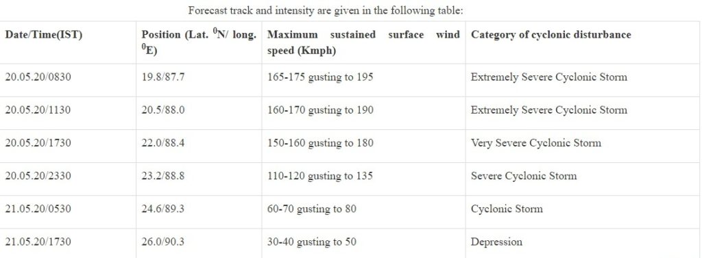
The Department has also issued a Forecast Track and Intensity Table: