
New Delhi: According to the latest release (at 1320 Hrs. IST) by the National Weather Forecasting Centre/Cyclone Warning Division of the India Meteorological Department:
The Super Cyclonic Storm ‘AMPHAN’ (pronounced as UM-PUN) over Northwest Bay of Bengal moved north-northeastwards with a speed of 29 kmph during past 06 hours and lay centred at 1130 hrs IST of today, the 20th May, 2020 as an Extremely Severe Cyclonic Storm over Northwest Bay of Bengal near latitude 20.6°N and longitude 88.0°E, about 140 km east-northheast of Paradip (Odisha), 125 km south-southeast of Digha (West Bengal), 125 km nearly south of Sagar Islands and 125 km southwest of Khepupara (Bangladesh).
It is very likely to move north-northeastwards and cross West Bengal – Bangladesh coasts between Digha (West Bengal) and Hatiya Islands (Bangladesh) close to Sundarbans during late Afternoon to Evening hours of today, the 20th May 2020 with maximum sustained wind speed of 155-165 kmph gusting to 185 kmph. Landfall process to commence from today late afternoon (1600 hours IST of today onwards). After landfall the system is likely to move north-northeastwards close to Kolkata.
The system is now being continuously tracked by the Doppler Weather Radar (DWR) at Paradip (Odisha) and Gopalpur (Odisha) and Kolkata (West Bengal).
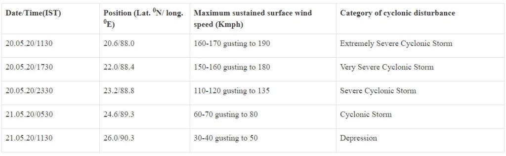
Forecast Track and Intensity are given in the following table:
Heavy Rainfall Warning:
Odisha: Heavy to very heavy rainfall very likely at isolated places over north coastal Odisha (Balasore, Bhadrak, Mayurbhanj, Jajpur, Kendrapara and Keonjhargarh Districts) and isolated heavy falls over Jagatsinghpur district on 20th May 2020.
West Bengal: Rainfall at most places with heavy to very heavy falls at a few places & extremely heavy falls at isolated places likely over Gangetic West Bengal (east & west Medinipur, south & north 24 Parganas, Howrah, Hoogli, Kolkata and adjoining districts)on 20th May and isolated heavy rain over interior districts on 21st May, 2020.
Sub-Himalayan West Bengal and Sikkim: Light to moderate rainfall at most places with heavy to very heavy falls at a few places over Malda & Dinajpur districts on 20th May and over most of the districts of Sub-Himalayan West Bengal & Sikkim on 21st May, 2020.
Assam & Meghalaya: Light to moderate rainfall at most places with heavy falls at isolated places over Meghalaya on 20th May and heavy to very heavy falls at a few places over the western districts of Assam & Meghalaya on 21st May.
Wind Warning: West Bengal & Odisha
Gale wind, speed reaching 90 to 100 kmph gusting to 110 kmph is prevailing along and off Jagatsinghpur, Kendrapara, Bhadrak, Balasore and Mayurbhanj districts of Odisha. It will gradually decrease becoming 50-60 kmph by today evening.
It will gradually increase becoming 100 to 110 kmph gusting to 125 kmph along & off the Balasore & Bhadrak Districts of North Odisha from today afternoon for the next 06 hours.
Gale wind speed reaching 80 to 90 kmph gusting to 100 kmph is prevailing along and off West Bengal coast (east & west Medinipur, south & north 24 Parganas, Howrah, Hoogli, Kolkata Districts).
Gale wind speed reaching 155 to 165 kmph gusting to 185 kmph very likely along & off east Medinipur and north & south 24 Parganas districts and 110-120 kmph gusting to 130 kmph over Kolkata, Hoogli, Howrah and West Medinipur Districts of West Bengal during the time of landfall (20th afternoon to night).